Tygodnik OSM 839
We are looking for volunteers to help us translate! Please get in touch with us: info@weeklyOSM.eu
13/08/2026-19/08/2026
Mapping
-
The proposal for revising
lgbtq=*, authored by Spughetti, aims to make tagging of LGBTQ+ features more accurate. It does so by deprecating keys that don’t provide added information over existing keys, changing the formatting of keys, and introducing new sub-keys. The RFC period started on 12 August 2026.
A proposal, authored by Biff, suggests extending the highway=traffic_mirror node with a relation type=traffic_mirror that specifies how the traffic mirror is intended to be used for the specific highway. It extends the already defined role=from and role=to members of the relation, provides better guidance for their meaning and the selection of their location, and also covers additional situations such as bidirectional mirrors on curves and dead-angle mirrors. Additionally, the proposal defines a new and recommended role=visible member to indicate relevant ways (or nodes) that can be seen through the traffic mirror. The RFC period is open until 12 September 2026.
Community
-
Rphyrin developed Warlok, a web tool for identifying the top OSM contributors in a specific local neighbourhood.
-
Rphyrin compared the user experience of several OpenStreetMap-based routing apps, including brouter, OSRM, and Valhalla, to calculate the distance of an afternoon bicycle trip he had just taken.
-
Rtnf explained how to correct JOSM’s satellite imagery offset using survey control marks.
-
9_tab wrote an OSM User Diary entry about Via Crucis in Switzerland (
worship=stations_of_the_cross). The entry explains what to look out for to find them, presents a list of routes along stations of the cross in Ticino, Solothurn and others cantons of Switzerland, and describes how to map them.
OpenStreetMap Foundation
- The submission phase of community questions to the board candidates closed on 22 August. An official set of questions will be added by the facilitator on 6 September 2026.
Local chapter news
- Maggie Cawley has recapped the March Local Chapters and Communities Congress (LCCC), a two-hour virtual gathering of over 30 participants from Italy, Indonesia, Greece, the USA, Belgium, Kenya, Canada, Brazil, and Malawi, sharing updates from their local OSM communities. The OSMF Board also joined to report on a Sovereign Tech Fund grant of €384,000, a new local chapter in Colombia, and plans for a Belgian subsidiary, before attendees worked through discussion prompts on what makes OSM hard to join and what keeps mapping communities going. The next in-person LCCC session will take place at State of the Map on 28 August in Paris. You can also join a monthly LCCWG meeting. Contact local@osmfoundation.org.
Events
-
Christopher Lorenz and Oliver Rudzick reported ► that FOSSGIS set up a stand at this year’s Maker Faire in Hannover and organised a stand for the OpenStreetMap project at FrOSCon in Sankt Augustin.
-
The French National Institute of Geographic and Forest Information posted ► on its website about the State of the Map 2026: ‘For the first time in twenty-two years, the OpenStreetMap community’s global conference will be held in France, in Champs-sur-Marne, near Paris, on the last weekend of August!’
Maps
-
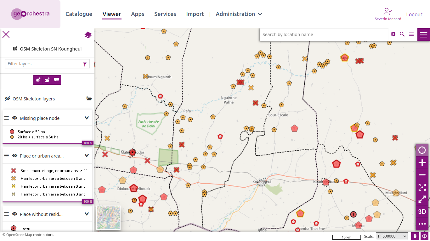
^[1]^ Following the launch of the OSM Skeleton methodology (we reported earlier), Séverin Ménard wanted to illustrate it with an example by resolving the main reports in an area of Senegal, where the demo is currently being deployed, in order to achieve a first milestone in data homogeneity. He also created a statistics dashboard to track the progress for each type of report between 5 and 19 August, when he was mapping for this case study.
-
Sylvain Machefert has developed Boîtes-à-livres ►, an OpenStreetMap-powered, collaborative database of public bookcases in France.
-
Nicolas Wurtz tooted that the OpenStreetMap France community recently released Tchoo, a web map that shows old railway lines from around the world in a retro style.
-
Papamap is a web map that displays locations tagged with
changing_table=yes, specifying the availability of changing tables where parents can change their babies’ nappies and highlighting which parent may be able to do it. The map has data from 11 countries in Europe and those places are colour-coded by location. It also includes a related MapComplete theme and an upcoming StreetComplete quest to improve the completeness of tagging information regarding changing tables.
OSM in action
-
Elias Probst tooted that OpenStreetMap data is once again being used to coordinate firefighting efforts in Hürtgenwald, Germany.
-
Shannon Connellan reported on DeFlock Maps, a crowdsourced app aiming to promote ‘surveillance transparency’ by pinpointing the locations of automated licence plate readers on a map.
-
DVLPLONDON developed ► Hop Earth, a multiplayer, browser-based racing game that uses real-life street data from OpenStreetMap as its race tracks.
Software
-
Uggla released AquaTrace version 0.5.0, which analyses GPX routes and displays nearby drinking water points using OpenStreetMap data, along with distance, elevation gain and loss, and an elevation profile.
-
DMH_AU has built the GPX Reference Point Generator, a web tool for generating GPX reference point files based on local government survey control marker plaques, helping OSM armchair-mappers to map more accurately.
Programming
- Stadia Maps explained how to use MapLibre React Native to write map code once and deploy it on both iOS and Android.
Did you know that …
-
… Thomas developed Fedihood? This is a Fediverse-based microblogging platform that lets users connect with other users in the same city, powered by the ActivityPub protocol and OpenStreetMap.
-
… the OpenJUMP is an open source geographic information system written in Java? It was developed primarily in Canada and is developed and maintained by a group of volunteers from around the globe.
-
… there is a table that summarises the values of
admin_levelfor various countries around the world (related to administrative levels)? And this is related to each country’s organisation? You can also check out an interesting discussion in this Hacker News thread. -
… deleting an OSM object does not actually erase the object from the OSM database? Instead, it creates a new version of that object whose state is
visible=false. The object’s ID, previous versions, tags, geometry, and history remain available. -
… Steve Coast, OpenStreetMap’s creator, delivered a special keynote ‘OpenStreetMap (almost) at 20: Reflections and Future Predictions’ at the State of the Map Europe 2023?
OSM in the media
- CHIP has rated ► OsmAnd+ as a ‘good’ navigation app.
Other “geo” things
-
USGS has released several visualisations related to the magnitude 7.4 earthquake that struck western Colombia on 10 August 2026.
-
The National Geographic Institute of Spain has published ► a web portal providing information on the solar eclipses that will be visible from Spain in 2026, 2027, and 2028.
-
yle noted ► that Yandex Maps has pioneered a new method for concealing military installations in satellite images; instead of blurring and pixelation, it now uses retouching with surrounding objects, such as forests.
-
Lindsey Lanquist reported that the Google team recently improved the GNSS on their Pixel Watch 5 by using three-dimensional models of buildings from Google Maps to cut down on errors caused by signal interference, as well as leveraging Google’s existing network of global GNSS reference stations.
-
Hans van der Kwast explained how to publish a QGIS project to the Mergin Maps platform, making it accessible online.
Upcoming Events
| Country | Where | Venue | What | When |
|---|---|---|---|---|

|
Potsdam | MachBar | Potsdamer Mappertreffen × 218. OSM-Stammtisch Berlin-Brandenburg  |
2026-08-21 |
|
|
Stadtgebiet Bremen | Online und im Hackerspace Bremen | Bremer Mappertreffen |
2026-08-24 |
|
|
Berlin | Online | OSM-Verkehrswende #78 |
2026-08-25 |
|
|
Würzburg | FabLab Würzburg | Würzburger OSM-Treffen |
2026-08-26 |
|
|
Düsseldorf | Online bei https://meet.jit.si/OSM-DUS-2026 | Düsseldorfer OpenStreetMap-Treffen (online) |
2026-08-26 |

|
Wien | Schlupfwinkel (Kleine Neugasse 10, 1040 Wien) | 79. Wiener OSM-Stammtisch |
2026-08-26 |
| OpenStreetMap West Bengal Mapping Party + AnkushTheHero Day |
2026-08-27 | |||

|
Cité Descartes | State of the Map 2026 |
2026-08-28 - 2026-08-30 | |
|
|
Essen | Verkehrs- und Umweltzentrum | Essen OSM-Treffen |
2026-08-28 |

|
Uppsala | Datorföreningen Update | Mapping meetup in Uppsala |
2026-08-30 |
|
|
Hannover | Kuriosum | OSM-Stammtisch Hannover |
2026-08-31 |
|
|
Heidelberg | DEZERNAT#16 | Rhein-Neckar OSM Treffen |
2026-08-31 |
|
|
Salzburg | Bewohnerservice Elisabeth-Vorstadt | OSM-Treffpunkt |
2026-09-01 |
|
|
Münster | BRASSERIE Münster | OSM-Stammtisch Münster |
2026-09-01 |
| Missing Maps London Mapathon Beginner Friendly (with Training) (Online) [eng] |
2026-09-01 | |||

|
Praha | Přírodovědná fakulta Univerzity Karlovy | SOTM/2 CZ |
2026-09-02 |
|
|
Brno | Kvartální OSM pivo - SOTM/2 CZ [Brno] |
2026-09-02 | |
| OSM Indoor Meetup |
2026-09-02 | |||
|
|
Stuttgart | Biergarten Tschechen & Söhne | Stuttgarter OpenStreetMap-Treffen |
2026-09-02 |
|
|
Bordeaux | Aquilenet, 20 Rue Tourat, 33000 Bordeaux | Rentrée bordelaise du groupe local OpenStreetMap |
2026-09-03 |
|
|
Angers | L’Arrière Train, 3 rue de Frémur, Angers | Angers Rencontre mensuelle OpenStreetMap |
2026-09-03 |

|
नई दिल्ली | Jitsi Meet (online) | OSM India - Monthly Online Mapathon |
2026-09-05 |

|
臺北市 | MozSpace Taipei | OpenStreetMap x Wikidata Taipei #92 |
2026-09-07 |
This weeklyOSM was produced by MarcoR, MatthiasMatthias, Raquel Dezidério Souto, Strubbl, Andrew Davidson, barefootstache, derFred, miurahr, renecha.
We welcome link suggestions for the next issue via this form and look forward to your contributions.
Leave a reply