Tygodnik OSM 835
We are looking for volunteers to help us translate! Please get in touch with us: info@weeklyOSM.eu
16/07/2026-22/07/2026
Mapping campaigns
- Ranjeet Jadhav, of Mid-Day, reported that Jaipur-based long-distance hiker Manav Singh Shekhawat has mapped more than 2,000 km of trekking trails in the Sahyadri Mountains on OpenStreetMap after walking nearly 3,500 km across the range.
Community
-
In the latest OpenCage’s OpenStreetMap interview series, Matt Whilden spoke about his journey as an OSM mapper, his work supporting the community through the OpenStreetMap US Board, and his passion for creative mapping.
-
Jikke Meyer plans to map football stadiums on OpenStreetMap, starting from Botswana in Africa.
-
Volker Krause joined an in-person workshop at HTW Berlin to discuss topics related to mapping indoor spaces in OpenStreetMap.
Local chapter news
- OSM Malaga tooted that the Ruedas Redondas association, a cycling users’ association in Malaga, has added a bicycle parking map ► to its website based on OpenStreetMap data. As they explained on their website, it is the ‘most complete and up-to-date’ bicycle parking map of the city, thanks to the collaborative work of the local OSM community.
Maps
-
Nicolas Seriot has developed Cartopolis, a web app that renders OpenStreetMap data in a map style reminiscent of the late 1990s.
-
HeiGIT presented a custom openrouteservice instance for disaster response in Venezuela, combining OpenStreetMap with real-time road-blockage data from HDX to dynamically route humanitarian vehicles around damaged or impassable infrastructure.
-
Jaz Michaelking developed Fediverse Near Me, a web map based on OSM that visualises a curated selection of well-moderated social web providers that are open for registration and serve specific countries, regions, or cities.
-
Alessandro Lorenzi has created OpenStreetPhoto, an interactive map that displays all the photos linked to a feature in the OpenStreetMap database. It is currently only available for Italy.
-
Using the world’s restaurant data from OpenStreetMap, Vladimir Terentyev has developed a world map of dish names on restaurant signs, attempting to answer the research question: ‘Where does plov end and biryani begin, and who really draws these limits’?
OSM in action
- Stefan Keller presented two web mapping applications built on OpenStreetMap and open government data. VivaMap combines OSM POIs and buildings with official datasets to let users build customised quality-of-life indicators for Swiss neighbourhoods, while UrbanistMap lets communities collaboratively geolocate and visualise urban development projects worldwide. UrbanistMap is well suited to encouraging mappers with local knowledge to update the data in OSM.
Software
-
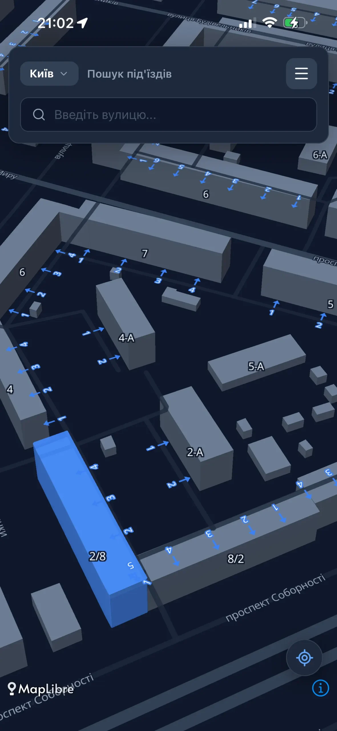
^[1]^ Oleksandr Nazarenko has built Pidyizdy, a navigation app focused on showing the exact location of building entrances and apartment number ranges. It is designed for couriers, taxi drivers, and utility service workers, so they don’t have to wander around apartment yards searching for the entrance.
-
Pavel Gavrilov tried darkonus’ recently released JOSM plugin, FilletTools (we reported earlier). The plugin allows users to round the corners of lines and polygons, as well as convert freehand strokes into smooth ways. Pavel praised FilletTools, noting that new JOSM plugins rarely have such a strong case for becoming a standard tool in many users’ workflows.
-
AnyFinder, originally released as a freemium app in 2019 for iPhone and iPad, is now available as a free browser-based application for finding, adding and editing OpenStreetMap places from phones, tablets, or desktop computers. AnyFinder uses Overpass and Postpass as its backend query engines. The app’s catalogue currently contains 286 place categories in 66 groups, from restaurants and shops to public services and natural features.
Categories define what kind of place to search for, while 128 filters refine results by properties such as wheelchair access, cuisine, fuel type, or available facilities. The current dataset covers 47 structured features and 435 OSM tags. Changes to places can be submitted directly to OpenStreetMap through the app using an OpenStreetMap account.
-
Tina and Eugene introduced OsmAnd’s measuring tools, including Distance by Tap, Ruler, Radius Ruler, and Target Line.
-
Tina and Eugene reported also that OsmAnd has discontinued ‘merged’ maps, which were large country- or region-level files assembled from smaller regional maps. Users who have one of these maps installed will no longer receive updates for it.
-
David Larlet reported that uMap has received a grant through the NGI0 Commons Fund to integrate vector tiles into uMap. The current work is focused on vector tile customisation, allowing users to modify the map style, such as removing buildings or changing road colours, so the basemap can better fit the purpose of their map.
-
Stadia Maps explained that moving from a geocoding prototype to a production-level application often reveals a frustrating reality: ‘standard’ industry pricing is rarely as simple as it looks. Most caching solutions charge steep premiums (often 6–8x normal query cost) to store results, and some impose strict rules limiting caching to single-user sessions only.
-
OSM user SmallCat has published josm-account-manager, a plugin that lets you manage multiple account profiles and different endpoints in JOSM. It is available for installation from JOSM‘s plugin source.
-
Koharachan announced , in her OSM User Diary, a fork of iD she is working on, and described its special features that ease mapping. She said that this editor introduces some AI assistance.
-
Fedilab developed PawFed, a collaborative map for animal welfare. Mention @PawFed from your Mastodon account with relevant hashtags and a location, and your report will appear on the map. Shelters, veterinary clinics, lost or found animals, food donations, and other information that can help animals are displayed on the map.
-
Venetis Charalampidis reported on the progress of the closures.osm.ch Google Summer of Code 2026 project, noting that one of its goals, adding a Valhalla-powered routing endpoint that genuinely avoids closed roads, has now been completed.
Programming
-
Marcos Dione has developed a map showing the sizes of city blocks in Marseille by processing the street network data from OpenStreetMap.
-
The Austrian-German OSM tile hoster Maptoolkit has launched a free vector tile server that permits commercial use. The cartography features rather opinionated cartography, with a focus on tourism and outdoor, including outdoor-specific styles (Hiking, Cycling, Winter), global hill-shading, contour lines, water depths, 3D terrain, and a maximum data zoom of 15 globally. It is hosted in the EU and privacy-friendly: No API key, login, or cookies. Fully compliant with the General Data Protection Regulation (GDPR). This service supports custom style sheets, including a new, beginner-friendly map editor at mapmaker.maptoolkit.org. It includes AI-ready documentation. You’ll also find an interesting comparison with OpenFreeMap, Protomaps, Versatiles, and OpenMapTiles on the page.
Releases
- uMap version 3.8.0a4 was released on 18 July 2026.
Did you know that …
- … Observing the City has made ‘Where is Downtown’? This is a web app that lets users draw what they consider to be the ‘downtown’ of a given city and compares their definition with everyone else’s.
OSM in the media
- The online magazine Konvert featured articles on volunteer projects such as Wikipedia, OpenStreetMap, iNaturalist, Project Gutenberg, and Stack Overflow, and spoke ► to some of the participants of these projects.
Other “geo” things
-
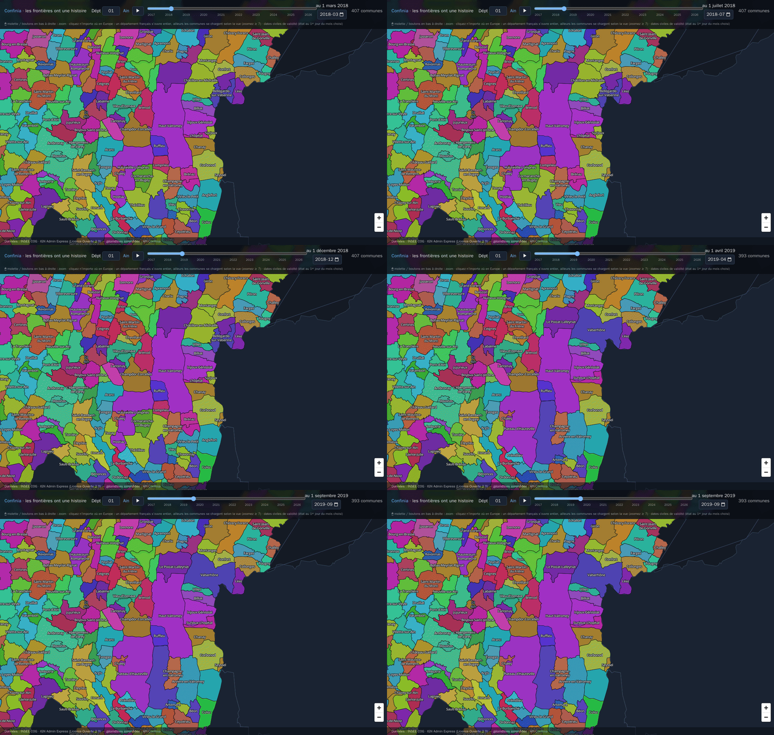
clement_igonet revealed on OSM US’s Slack that he had built a small MapLibre application that shows a time-slider over European administrative boundaries, where the polygons come from an API that models them with valid periods (from sources as INSEE COG, IGN Admin Express and Eurostat GISCO, all open data, no OSM data involved for now). The demo is available. You can watch a short video. The API in the background is api.confinia.io and the source is available on GitHub.
-
The NOAA Office for Coastal Management runs four major programmes, one of which is the Digital Coast. In this context, the Sea Level Calculator has been launched, which estimates scenarios for changes in mean sea level, showing the sections of the coastline that would be affected (in monitoring regions). To assist researchers and other users, a series of short videos has been made available.
-
HeiGIT has launched a new newsletter, Point of Interest. The first issue focuses on the latest evolution of openrouteservice, its newest developments for humanitarian (and other) uses, and where HeiGIT is heading next.
Upcoming Events
| Country | Where | Venue | What | When |
|---|---|---|---|---|
MapCup Asia Pacific 2026  |
2026-07-01 - 2026-07-31 | |||

|
Hotel Sadanand, Crawford Market | OSM Mumbai Mapping Party No.12 (Masjid Bunder) |
2026-07-26 | |

|
Online | Racha Mapping Party |
2026-07-27 - 2026-08-02 | |

|
Braunschweig | Stratum 0 | Braunschweiger Mappertreffen im Stratum 0 Hackerspace |
2026-07-28 |
|
|
Kiel | Mango’s, Kiel | Kieler Mapper*innentreffen |
2026-07-28 |
|
|
Berlin | Online | OSM-Verkehrswende #77 |
2026-07-28 |
|
|
Mannheim | RaumZeitLabor, Mannheim | Rhein-Neckar OSM Treffen |
2026-07-29 |
|
|
Düsseldorf | Online bei https://meet.jit.si/OSM-DUS-2026 | Düsseldorfer OpenStreetMap-Treffen (online) |
2026-07-29 |
| UN Mappers Community Discussion: Community Chapters Initiative |
2026-07-31 | |||
|
|
Hannover | Endhaltestelle Roderbruch der Stadtbahnlinie 4 | Mapping Party |
2026-07-31 |
|
|
Thiruvananthapuram | Kazhakoottam Market bus stop | Mapping Party at Kazhakoottam |
2026-08-01 |

|
Uppsala | Datorföreningen Update | Kartträff i Uppsala. Tema Cykelinfrastruktur |
2026-08-02 |

|
Salzburg | Bewohnerservice Elisabeth-Vorstadt | OSM-Treffpunkt |
2026-08-04 |
| Missing Maps London Mapathon (with Training) Beginner Friendly (Online) [eng] |
2026-08-04 | |||
| iD Community Chat |
2026-08-05 | |||
|
|
Stuttgart | Biergarten Tschechen & Söhne | Stuttgarter OpenStreetMap-Treffen |
2026-08-05 |

|
Angers | L’Arrière Train, 3 rue de Frémur, Angers | Angers Rencontre mensuelle OpenStreetMap |
2026-08-06 |
|
|
Bar Le Schmilblik | Rencontre mensuelle des contributeurs Paris sud |
2026-08-06 | |

|
København | Cafe Bevar’s | OSMmapperCPH |
2026-08-09 |
|
|
New Delhi | North Delhi | OSM Delhi Mapping Party No.31 (North Zone) |
2026-08-09 |

|
臺北市 | MozSpace Taipei | OpenStreetMap x Wikidata Taipei #91 |
2026-08-10 |
This weeklyOSM was produced by MatthiasMatthias, Raquel Dezidério Souto, Strubbl, Andrew Davidson, barefootstache, derFred, 快乐的老鼠宝宝.
We welcome link suggestions for the next issue via this form and look forward to your contributions.
Leave a reply