주간 OSM 836
We are looking for volunteers to help us translate! Please get in touch with us: info@weeklyOSM.eu
23/07/2026-29/07/2026
Mapping
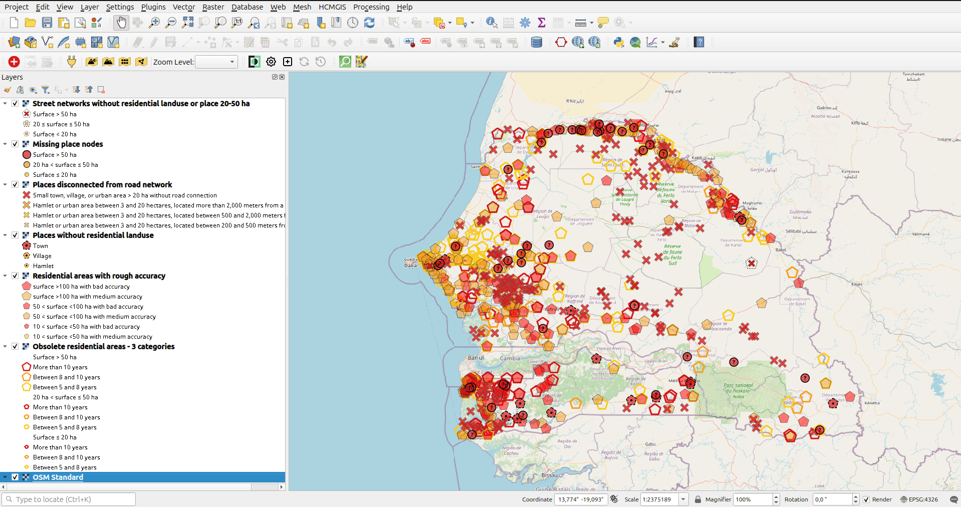
- ^[1]^ Les Libres Géographes has shared a methodology called OSM Skeleton, which aims to reduce the heterogeneity of OpenStreetMap data to create a coherent and locally maintainable common dataset of geographic references. The approach systematically identifies, on a national scale, missing, incomplete, inaccurate, or obsolete features among those considered fundamental: place nodes, road network, and residential areas. It uses a hybrid feature called ‘urban areas’ for analytical purposes. In particular, it generates WMS layers of alerts, instruction pages for easily correcting them in JOSM or iD, tracking statistics, and also a score for the density of POIs in towns. Séverin Ménard will present it at the upcoming SotM in Paris.
Community
-
ASRvwde shared a collection of various mapping tools that support OSM mapping activities.
-
Calvin Amevienku, YouthMappers Regional Ambassador to Ghana, has coordinated his first end-of-year mapathon under his working plan for 2026. The initiative organised training for 25 YouthMappers on how to use JOSM and the HOT Tasking Manager. The activity was sponsored by the IVIDES DATA, from Brazil, and the organisers hope the next steps will help improve the mapping skills of the YouthMappers chapter at the University of Education - Winneba.
-
Nile_thebest explained that his passion for mapping on OpenStreetMap has never really faded since he first registered more than 11 months ago.
-
Christoph Hormann has written a blog post responding to a OSM Community forum discussion about the OSMF’s AI and chatbot policy, under which moderators may delete AI-generated text or images and have been advised to use the Pangram detection tool. He argues the controversy stems from combining moderator authority with technocratic platform management, leaving forum participants without the tools or experience to manage their own social interactions. Drawing on Usenet-era killfiles, he suggests LLM use by human participants would be less contentious if users could individually filter content rather than have it collectively regulated. He concludes that the dispute reflects an unconsidered attempt to centrally control what people write and read, instead of giving them individual freedom to manage it themselves.
-
Rphyrin pondered the ethics of conducting large-scale mapathon campaigns after learning that, in a certain neighbourhood, the locals deliberately preferred to make internal navigation difficult for outsiders to increase the security of the neighbourhood’s residents.
Local chapter news
- OpenStreetMap US’s July 2026 newsletter has been published.
Events
- OSM US tooted that the SOTMUS 2026 videos are available on its YouTube channel. There are almost 60 videos available in the playlist.
OSM research
- Robert Klar and David Gundlegård applied machine learning to predict zonal travel demand using OSM-derived built environment features, including land use, points of interest, and road network attributes, combined with population estimates from WorldPop, in two case study cities: Stockholm and Norrköping. Their research shows that OSM features, particularly those related to residential land use, buildings, and POIs (e.g. companies, healthcare facilities, and public transportation), are strong predictors of zonal travel demand.
Maps
-
EclipseMap is an interactive map by Alessio Zanol that allows users to explore the visibility of the solar eclipse on 12 August across Europe. The map shows whether the solar eclipse will be total or partial at a selected location. The app uses OpenStreetMap-based vector tiles from OpenFreeMap as its base map.
-
The Agroecology Map is an interactive web map based on OpenStreetMap, maintained by Marcelo S Souza and Eduardo F Formighieri, which showcases agroecological initiatives, as well as records of places and practices. It is intended to promote the sharing of open knowledge and strengthen collaborative networks across different regions. The source is available on Codeberg.
-
The Flosm Power Grid is a web map showing the global infrastructure of electricity grids, from high to low voltage, with substations and power plants, all based on OSM data. The elements can be visualised individually via a fold-out selection bar to the left of the map. It is maintained by 123map GmbH & Co.KG and hosted at 123map.de. You can see the set of tags used by this project on taginfo.
OSM in action
-
Equidistance.io has analysed OpenStreetMap data and declared The Greene Man on Euston Road to be London’s most equidistant pub. Based on public transport journeys from where residents of all 33 London boroughs actually live, no borough requires more than 70 minutes to reach the pub, with a travel time difference of just 47 minutes between the nearest and furthest boroughs.
-
Following Czechia, #geoweirdness turned its attention to proposed national mergers, such as ‘Pan-Iberism’ between Spain and Portugal. Today, the idea has lost momentum since both countries are now part of the EU.
-
Denjam used OpenStreetMap data to answer the question: ‘What proportion of beauty salons in a particular city allow customers to book online without having to ring first’?
Software
-
The openstreetmap-website project celebrated 20 years since the first commit with some old screenshots of a very different era.
-
Soon, when uploading a GPX trace to OSM, you will no longer be able to choose some of the visibility levels, as the website development team is working to simplify and improve the GPX trace management system.
-
OSM2CDR is a web service that exports OpenStreetMap data for any drawn area or administrative boundary into 62+ formats aimed at non-GIS users, CorelDRAW CDR, AutoCAD DWG/DXF, SVG, STL for 3D printing, and dozens of other formats, keeping map layers editable and clipping exports to administrative boundaries. The catalogue offers about 2.9 million ready to use admin areas in 193 countries. There is also a blog with rich content. The ODbL attribution is embedded in every export.
-
OWL Places can now work in reverse: adding OpenStreetMap links to Wikidata.
Programming
-
Juno Computers have developed Car Navigation, a navigation app for Linux systems. It uses OpenStreetMap data and services for place search and route planning, including Photon, Nominatim, OSRM, and Valhalla.
-
Andy Townsend has updated his diary entry describing how to set up an Overpass API server, covering data for Britain and Ireland only (we reported earlier). The guide is a response to the ongoing overload of public Overpass servers and uses an actively maintained forked version of the Overpass software. The guide walks you through server setup on Hetzner cloud hardware, Apache configuration, compilation, and loading data from a Geofabrik extract. The post also links to other installation guides, including Brian Sperlongano’s guide and an earlier diary entry by Kai Johnson.
-
Milan Janosov shared an urban data science reading list, including a hands-on path from your first OpenStreetMap query to city-scale spatial models.
Releases
- Baba version 1.22.1 for Panoramax contributions from Android has been released.
Did you know that …
-
… BeMaps.es? BeMaps is a web-based mapping tool that allows you to create and share maps in three steps: upload data, select a map template, and publish or share with specific recipients. This tool offers pre-prepared data layers for regions around the world. BeMaps was developed by the GEOT (Geography) and IAAA (Information Systems) research groups at the University of Zaragoza, in collaboration with the company Geoslab. As well as a free version, there are paid plans available for educational purposes, non-profit organisations, and standard use.
-
… Milan Janosov posted, on Substack, a short guide ‘OpenStreetMap vs Global Building Atlas (GBA) Explained’? It includes Python scripts to extract buildings from OSM and the GBA, a new dataset from the Technical University of Munich covering 2.75 billion buildings worldwide, derived from satellite imagery and deep learning (we reported earlier).
Other “geo” things
-
The Digital Encyclopedia of Africa compiles the civilisations, languages, myths, architecture, and living traditions of indigenous communities across the continent. The website has an interactive map and is full of city profiles which are based on open archives (UNESCO, museums, public libraries), alongside premium and scholarly sources for deeper research.
-
Arte is showing the video ‘Contre-cartographie: What Google Maps Doesn’t Show You’. Two French artists feature in it: Larissa Fassler and Mathias Poisson. They explain the concept of counter-cartography. This approach challenges our usual relationship with space. It also questions how we normally represent the world. This brings to light issues that would otherwise go unnoticed. The video has subtitles in English, Spanish, Polish, and Italian.
-
Werner Pluta, of Heise, reported that researchers from RWTH Aachen, ETH Zurich, and the Italian Istituto Nazionale di Geofisica e Vulcanologia triggered an artificial earthquake with a magnitude just below zero in the Alps as part of an experiment to improve future earthquake prediction.
-
While Joël Lapointe, an amateur astronomer, was planning a camping vacation in 2024 he observed a strange 25 km depression near lake Marsal, north of Magpie in Quebec, that looked like a meteor crater in satellite imagery. Alerted geologists explored the site and confirmed the discovery of this previously unidentified 390-million-year-old Uhackatik meteor crater. The name was chosen in consultation with the Innu Council of Ekuanitshit.
-
Jnally, of Spatial Source, reported that Andrii Rohovyi recently improved the routing algorithm of OpenTripPlanner. Rohovyi explained their improvement in a preprint, ‘Early Pruning for Public Transport Routing’, available on arXiv.
Upcoming Events
| Country | Where | Venue | What | When |
|---|---|---|---|---|

|
Online | Racha Mapping Party  |
2026-07-27 - 2026-08-02 | |
| UN Mappers Community Discussion: Community Chapters Initiative |
2026-07-31 | |||

|
Hannover | Endhaltestelle Roderbruch der Stadtbahnlinie 4 | Mapping Party |
2026-07-31 |

|
Thiruvananthapuram | Kazhakoottam Market bus stop | Mapping Party at Kazhakoottam |
2026-08-01 |

|
Uppsala | Datorföreningen Update | Kartträff i Uppsala. Tema Cykelinfrastruktur |
2026-08-02 |

|
Salzburg | Bewohnerservice Elisabeth-Vorstadt | OSM-Treffpunkt |
2026-08-04 |
| Missing Maps London Mapathon (with Training) Beginner Friendly (Online) [eng] |
2026-08-04 | |||

|
San Jose | Online | South Bay Map Night |
2026-08-04 |
| iD Community Chat |
2026-08-05 | |||
|
|
Stuttgart | Biergarten Tschechen & Söhne | Stuttgarter OpenStreetMap-Treffen |
2026-08-05 |

|
Angers | L’Arrière Train, 3 rue de Frémur, Angers | Angers Rencontre mensuelle OpenStreetMap |
2026-08-06 |
|
|
Bar Le Schmilblik | Rencontre mensuelle des contributeurs Paris sud |
2026-08-06 | |

|
臺北市 | 國立臺灣科技大學研揚大樓412-1教室 | COSCUP 2026 State of the Map Taiwan 2026 / Wikidata Community Summit 2026 |
2026-08-09 |

|
大阪市 | 11F, Urban Net Midosuji Building, 4-2-13 Awajicho | OpenStreetMap関西カンファレンス2026 / OSM Kansai Conference 2026 |
2026-08-09 |

|
København | Cafe Bevar’s | OSMmapperCPH |
2026-08-09 |
|
|
New Delhi | North Delhi | OSM Delhi Mapping Party No.31 (North Zone) |
2026-08-09 |
|
|
臺北市 | MozSpace Taipei | OpenStreetMap x Wikidata Taipei #91 |
2026-08-10 |
|
|
Hamburg | Voraussichtlich: “Variable”, Karolinenstraße 23 | Hamburger Mappertreffen |
2026-08-11 |
|
|
temporärhaus | OSM-Stammtisch Ulm/Neu-Ulm |
2026-08-11 | |
| Missing Maps Online Mapathon von Ärzte ohne Grenzen |
2026-08-12 | |||
|
|
München | Echardinger Einkehr | Münchner OSM-Treffen |
2026-08-12 |
| UN Mappers Mappy Hour |
2026-08-13 | |||
|
|
Hochschule Rhein-Sieg | OSM auf der FrOSCon 2026 in Sankt Augustin |
2026-08-15 - 2026-08-16 | |
|
|
Hannover | Hannover Congress Centrum | OSM auf der Maker Faire Hannover 2026 |
2026-08-15 - 2026-08-16 |
|
|
नई दिल्ली | Jitsi Meet (online) | OSM India - Monthly Online Mapathon |
2026-08-15 |
|
|
Stadt- und Waagenmuseum Oschatz | Kartenwerkstatt Oschatz |
2026-08-16 |
This weeklyOSM was produced by MarcoR, MatthiasMatthias, Minh Nguyen, Raquel Dezidério Souto, SeverinGeo, Strubbl, Andrew Davidson, barefootstache, derFred.
We welcome link suggestions for the next issue via this form and look forward to your contributions.
Leave a reply